April 21, 2017
Traditional Wayfinding: Ancient Navigation through the Pacific
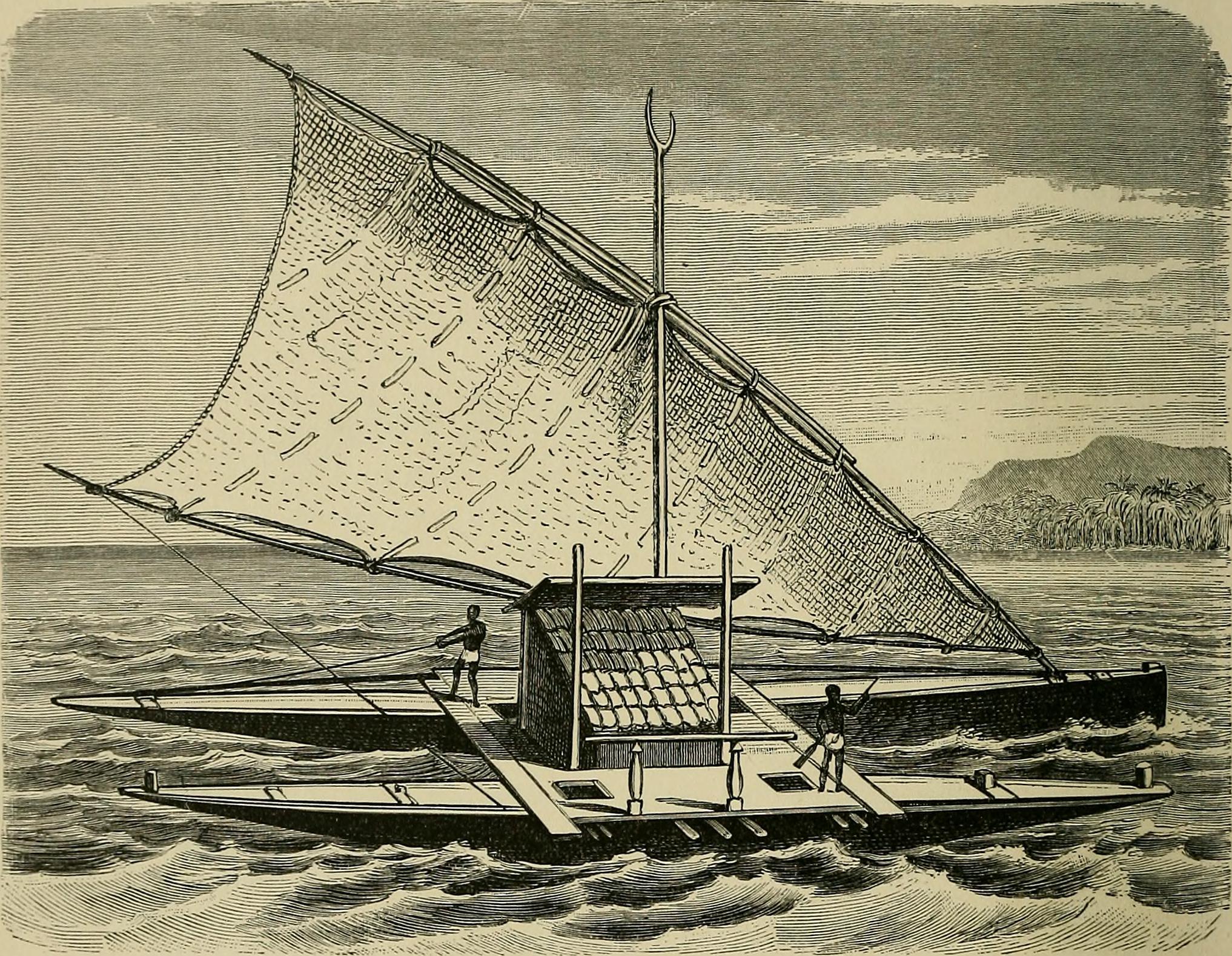

Traditional wayfinders of Polynesia, Micronesia, and Melanesia relied solely on natural elements such as celestial bodies, the winds, swells, the climate, and birds to navigate their way through the vastness of the Pacific Ocean. Traditional wayfinding is the practice of navigating that encompasses these natural elements to provide guidance on voyages. Pacific Islanders shocked early English sailors with their ability to manage long distance voyages, a practice that dates back to about 3000 BCE. This incredible practice begs the question: how were these people able to navigate without any aid from the kinds of navigational tools that we often use today? One answer that has been argued by cultural scientist Harald Haarmann is that they were able to instrumentalize their “refined perception of natural phenomena.”1
Wayfinding was not always recognized as an established talent of ancient Pacific Islanders. Early-modern Europeans believed that early Polynesians had probably drifted off-course during routine travel and accidentally discovered islands throughout Oceania. It was not until Captain James Cook observed the native people of the Hawaiian Islands that the notion that they had advanced navigation techniques slowly started coming into light.2 The earliest estimated movement of people to Oceania was between 3200 and 2800 BCE.3 After more extensive studies, archaeologists today have been able to determine that ancient Pacific Islanders had settled several islands before they came in contact with European settlers. Evidence shows that between 1290 and 1120 BCE, islands of Melanesia and Micronesia were being settled. In another flow of migration between 1120 to 1025 BCE, a period of heavy migration to islands such as Hawaii, Rapa Nui, and New Zealand took place.4 To understand how these voyages were successfully executed without the use of navigational instruments, we will look at some methods that wayfinders used in order to sail their way across the Pacific.

Master navigators began by calibrating their positions according to celestial objects, such as the sun, the moon, and constellations. Stars rise in the East and set in the West. They first chose a primary set of stars and constellations, which they knew would eventually set on specific points on the horizon. When the view of the horizon became obstructed, for example, by clouds, they would need to reference a secondary set of stars in the night sky. When this happened, navigators had to recalibrate themselves “by glancing at any section of the night sky, much as we can by glimpsing any part of a thoroughly familiar room.”5 When faced with challenges regarding the obstruction of their view of the sky, navigators resorted to their observations of other directional indicators to orient themselves. By referencing waves and ocean swells, or by observing certain birds, navigators could find indication of their proximity to land.
There are two forms of fluctuations that navigators referenced when observing the ocean itself. The first were ocean waves. Waves are ignited by local winds, which are winds that are confined to small spatial areas that range “from a few miles to 100 miles in width.”6 Waves were increasingly useful directional indicators when embarking on inter-island travels. On the other hand, navigators referenced swells during long distance voyages because they were not easily influenced by abrupt changes in wind patterns. The endurance of swells can last from a week to a month.7 Their consistency is what allow them to be exceptional directional indicators. Navigators also occasionally referenced certain types of birds to determine their location. While it may be unsure what birds ancient navigators used to detect their proximity to islands, we can look at how those that still practice traditional wayfinding use birds as an aid for navigation.8 There are two birds that serve as the most prominent indicators. The White Tern and the Brown Tern both sleep on islands at night and at dawn they embark on fishing trips. The Brown Tern is known to travel about 40 miles out to sea, while the White Tern can travel as far as 120 miles out. When wayfinders detect these birds in the day, they closely keep track of them. When the sun gets low and the birds retreat, they use their flight paths to indicate the direction of the island. “They know the island is close even though they cannot see it.”9
It is incredible that ancient voyagers acquired the skills to look and feel their way through the Pacific. Their lack of technical navigational tools did not hinder their travels.10 This craft is still heavily practiced throughout Oceania. Although the practice was under threat of modernization and westernization, the Polynesian Voyaging Society, which is based in Honolulu, Hawaii, has gone to great lengths to lead a revitalization of traditional wayfinding.
- Haarmann Harald and Claire Brennan, The Hawaiians and other Polynesian Seafarers Developed Navigation Methods Based on Observation of Constellations and Currents, So that They Could Sail Intentionally from Tahiti to Hawaii and Back (California: Santa Barbara, 2011), 262. ↵
- M. Walker, “Navigating Oceans and Cultures: Polynesians and European navigation systems in the late eighteenth century,” Journal of the Royal Society of New Zealand 42, no. 2 (June 2012): 93. ↵
- Fiona Petchey, Mathew Spriggs, Foss Leach, Christophe Sand, Michael Pieutrusewsky and Katy Anderson, “Testing the human factor: radiocarbon dating the first peoples of the South Pacific,” Journal of Archaeological Science 38, no. 1 (January 2011): 29. ↵
- Janet M. Wilmshurst, Terry L. Hunt, Carl P. Lipo, Atholl J. Anderson, “High-precision radiocarbon dating shows recent and rapid initial human colonization of East Polynesia,” Proceedings of the National Academy of Sciences of the United States of America 108, no. 5 (December 2010), 1815. ↵
- Ben R. Finney, “Re-Learning a Vanishing Art,” The Journal of the Polynesian Society 95, no.1 (1986): 43-44. ↵
- UXL Encyclopedia of Weather and Natural Disasters, 2008, s.v. “Local Winds.” ↵
- G.H. Heyen, “Primitive Navigation in the Pacific Part I,” The Journal of the Polynesian Society 71, no. 34 (1962), 68. ↵
- Taylor White, “On the Use of Birds in Navigation,” The Journal of the Polynesian Society 16, no. 2 (1907): 92-93. ↵
- Nainoa Thompson, “On Wayfinding,” Hawaiian Voyaging Traditions (Accessed March 2017), http://archive.hokulea.com/ike/hookele/on_wayfinding.html. ↵
- Haarmann Harald and Claire Brennan, The Hawaiians and other Polynesian Seafarers Developed Navigation Methods Based on Observation of Constellations and Currents, So that They Could Sail Intentionally from Tahiti to Hawaii and Back (California: Santa Barbara, 2011), 263. ↵
Tags from the story
Oceania
Pacific Islanders
Traditional Wayfaring
Recent Comments
Teresa Valdez
I love the way this article was approached. The skills of the Polynesian people developed this amazing skill to use nature to navigate is astonishing and in a way proves that technology is a little overrated. The detail that is put in this article is very well researched and is very understandable. Reading this article makes me think of Disney’s Moana, so it was delightful to get a sense of the history behind that story.
21/04/2017
9:35 am
Mario De Leon
This was a great article, good job! It amazes me how early humans used natural elements to navigate. It is very impresses they were able to travel long distances especially if they used ships like the one used in your featured image. It absolutely blows my mind that they would use the waves as a navigation tool. It’s amazing that their lack of technology did not stop them from exploration.
21/04/2017
9:35 am
Alyssa Vela
This was an amazing article! I think its amazing how someone could make so much out of so little. These people were able to navigate by something as simple as the stars/natural elements. I’ve always considered myself an observant person but I don’t think i would ever be as extreme as that. I doubt if I ever found myself on a boat in the ocean if I could navigate my way out so simply. Overall this was a great article! I look forward to reading more into it!
21/04/2017
9:35 am
Alyssa Valdez
I really enjoyed reading your article! I can tell you put a lot of time and research into your article! I thought it was very well organized and highlighted all the important information that needed to be said. I find it so fascinating how we as humans were able to survive on such minimal tools and technology! Just proves that anything is possible without technology!
24/04/2017
9:35 am
Luke Trevino
Wow very good article! It obvious you did a lot of reasearch and put plenty of work into your article. I loved it because it was very knowledgeable! What blew my mind was the navigation! They navigated using the stars and wind on a simple boat. It is so different From society today where we have GPS for everything and they had to know how to get every where. Like I said very good article!
26/04/2017
9:35 am
Bailey Rider
This is such an interesting article Irene! It is obvious that you put a lot of hard work into it so thank you. It was cool to learn that wayfinders relied on the elements to find their way through the ocean. That seems so scary to me, even just thinking about losing the way and getting lost! It was cool to learn how the simple signs taught them the way. Thanks for the great article!
27/04/2017
9:35 am
Mariana Govea
This was a very interested and fun article to read, it was definitely something I enjoyed. What really interested me the most was the fact that these wayfinders only used what was offered to them and even then that was not much, just their surroundings were resourceful. These explorers used a very simply boat to navigate through the ocean and I would definitely say they probably had to make their boat before sailing. Overall the article was great and organized well. Thank you for your article and your hard work!
28/04/2017
9:35 am
Sam Vandenbrink
This was an interesting read. I think it is important to understand human migrational patterns and how certain cultures came to settle different areas around the earth. The fact that ancient Polynesians had such useful navigational techniques is important to understand the development of their culture as reliant on sea navigation.
28/04/2017
9:35 am
Alexis Soto
Definitely a topic I knew almost noting about. It was interesting to learn about these ancient navigation techniques. I’ve always wondered how the people ended up in the island so its incredible to learn that they accomplished ocean navigation without the use of technology. I am also pleased to have learned that efforts have been made to make sure these outstanding techniques are kept alive.
28/04/2017
9:35 am
Johnanthony Hernandez
Interesting article, it still amazes me that Pacific Islanders had mastered long distant voyages like that using only basic navigational skills. As well as relying on natural factors to navigate before coming in contact with the Europeans. Great job on your article, it makes me want to learn more about these wayfinders.
21/04/2017
9:35 am